Evidence from a crime scene – a boot print, a tire track, a bloody glove – can give investigators the clues they need to bring persons committing crime to justice. However, conventional methods of collecting this information, including photography, charting, and terrestrial laser scanning, require forensic personnel to walk through the crime scene, risking evidence contamination as well as bodily harm from hazardous environments.
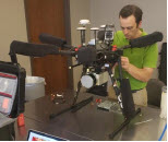
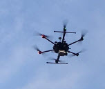
New drone-mounted sensing technologies could help investigators reconstruct crime scenes from the air without having to physically enter the space. National Institute of Justice-supported researchers from Kansas State University evaluated the use of small, unmanned aircraft systems (i.e., drones) equipped with two types of remote sensors for crime scene reconstruction and compared their performance to conventional terrestrial laser scanning.
Their findings showed that terrestrial laser scanning created more accurate images of staged outdoor crime scenes than the aerial methods. However, a combination of terrestrial and aerial scanning allowed faster data capture over the entire crime scene while maintaining a higher level of accuracy than either method on its own.
Study Design
Ground-based techniques for reconstructing crime scenes require highly trained personnel to enter a scene and time – both of which increase the risk of evidence contamination and destruction – and decrease data integrity. Kurt J. Carraway and his team evaluated aerial sensing technologies as a hands-free way to collect touch- and time-sensitive evidence at crime scenes. Their study investigated the advantages and limitations of two types of aerial sensing technologies – structure from motion photogrammetry and LIDAR – and compared their performance to conventional terrestrial laser scanners from the Kansas Bureau of Investigation in crime scene reconstruction and investigation.
The methodologies for the project included:
- Terrestrial laser scanning: A trained individual strategically places several laser scanners throughout the simulated crime scene. Scans are conducted simultaneously and are stitched together to create a 3D map.
- Structure from motion photogrammetry: 2D images from a digital camera mounted on a drone are used to reconstruct a 3D model of the simulated crime scene. The drone also carries a Global Positioning System to establish control points on the ground and lights for nighttime scans.
- Light detection and ranging (LIDAR): A LIDAR system mounted on a drone records the time it takes for a laser to hit objects on the ground and reflect back to a receiver. These measurements are combined and used to reconstruct 3D images of the simulated crime scene.
To test each method’s ability to assess a crime scene, the researchers worked with law enforcement partners to set up three outdoor scenarios at the Crisis City Training Center, a disaster training center for emergency response personnel near Salina, Kansas:
- An urban scene that resembled a carjacking and shooting with broken glass, bullet casings, trails and pools of fake blood, and firearms.
- A forest scene involving a suicide by hanging with pieces of clothing, empty alcohol containers, simulated narcotics paraphernalia, and rope.
- An open field with a clandestine grave with a shovel, cellphone, items of clothing – some partially buried, and restraints.
Data Collection and Study Results
Carraway and his team collected quantitative and qualitative data for each imaging method in each simulated scenario both at night and during the day.
Measurable error: The ground-based terrestrial laser scanning method maintained the lowest level of error of all three crime scene scenarios at about 1 mm. The aerial structure from motion method had the second-best level of error at about 1 cm and the aerial LIDAR method was last at about 3 cm.
Imaging detail and completeness: Terrestrial laser scanning produced the most complete and detailed scans for each scene. However, terrestrial laser scanning took longer than structure from motion and LIDAR scans and required personnel to physically enter the crime scene. Terrestrial laser scanning also produced blind spots if there were not enough scan positions or if there were obstacles the laser could not “see” around. The structure from motion method had no blind spots because it captured scene information from above. The LIDAR scans all had low levels of distinguishable detail, identifying only large features like buildings and cars.
Environmental limits: The biggest environmental challenge for all three methods was collecting high-quality data at night. While terrestrial laser scanning was able to preserve data quality at night, the images were limited to black and white. Structure from motion effectively collected data in urban and field scenarios during the day, but could not image the forest scenario because the higher drone altitude (to avoid hitting tree tops) reduced image quality. The structure from motion drone-mounted lights were not bright enough to allow image capture at night. The LIDAR system scans maintained a consistently low level of distinguishable detail for all crime scene scenarios during both night and day scans.
Cost: Conventional terrestrial laser scanning and drone-mounted LIDAR equipment costs about $75,000 and $70,000, respectively. The drone-mounted structure from motion platforms cost much less, averaging $15,000.
Discussion and Study Impact
The researchers encountered many study limitations, including low-yield LIDAR scans and only a few nighttime data sets. They also highlighted the need for a standardized method for determining measurement accuracy across all three remote sensing methodologies in order for the data to be considered statistically sound and accepted as physical evidence.
The researchers concluded, “models produced by sUAS [small unmanned aircraft systems] SfM [structure from motion] methods could provide criminal justice professionals and juries with the ability to review the scene in a complete and relatively unaltered state.” They also expect this study to be useful to “entities seeking opportunities to supplement existing terrestrial laser scanning data collection methods, as well as groups looking for a lower-cost alternative to crime scene reconstruction.”
The drone-mounted LIDAR system used in this study was deemed insufficient for crime scene data collection by the researchers because it did not produce images from which evidence could be identified. However, they note that they chose the Snoopy A-Series 60 LIDAR system because it is comparable in price to the terrestrial laser scanning system used in this study and that there are more advanced LIDAR systems on the market that could have performed better.
The researchers used information from the study to publish a document for the law enforcement community named “A Guide for Crime Scene Reconstruction Using Structure from Motion Techniques in Small UAS,” available in Appendix D of the grantee final report.
About this Article
The research described in this article was funded by NIJ grant 2018-R2-CX-0031, awarded to Kansas State University, Manhattan, Kansas. This article is based on the grantee final report “Evaluation of Terrestrial Laser Scanning and Aerial Remote Sensing with Small Unmanned Aircraft Systems for Forensic Crime-Scene Reconstruction” (April 2021) by Kurt J. Carraway.


